on repeated request of many of our clients we have summarized information on a current project not only on our website but also in the form of a compact newsletter. Hence, this is a trial, which is exclusively dedicated to the group of potentially interested clients and trade fair visitors (MUTEC/Munich, Exponatec/Cologne). The frequency of publication will presumably be irregular depending on the character of individual projects. Critical comments are welcome! If you don't wish further delivery of upcoming newsletters please send an empty email:
>>here
The Viking Settlement Haithabu
On behalf of Pflug-Gomaringen (CNC-specialist) data have been processed for the model reconstruction of the ancient Viking settlement Haithabu near Schleswig, northern Germany. The model is part of a larger relaunch of the local Viking museum, which has been carried out by space4, Stuttgart.
The first step was to optimise the given digital elevation model for the cnc-milling process of the underlying solid terrain model.
Subsequently a quite intensive remapping and systematic transformation of the settlement geometry in GIS format had to be completed as the necessary precursor of the following surface design of the model.
Map of settlement
Finally the model designer had to put in place
a very intricate infrastructure of
ramparts, moats, lanes and harbour facilities,
not to mention the more than 2500 partly very small-scale model
houses.
Solid Terrain
Model
While processing the digital elevation model
the removal of modern surface attributes was vital in favour of the
assumed historical situation. This encroachment upon the digital
elevation model was even more considerable since we had to deal with a
particularly high-resolution data set of 1-meter mesh width.
With this high data density rather small morphological attributes
left: original 1m elevation data set
right: reprocessed data
are visible such as hedges, woods, individual
trees, ditches, roads and houses that are all of a modern nature.
All these mostly elevated features had to be removed or flattened.
Furthermore the impressive moat-and-rampart structures do not
reflect the assumed defence system of the 8th century. We removed
them too, however mechanically after the cnc-milling process had
finished and replaced them by elements of more appropriate
proportions.
Surface Design
Based on the data processing and programming
of a graphical support software by QUOMODO.de the model designer
could start his job.
Raised objects such as houses, ramparts and
harbour facilities have
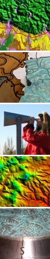
left: while placing houses, digital
positioning system
right: "Main Road" of Haithabu
been placed individually. Convex structures
such as lanes, moats and a small creek were processed directly by
cnc-milling into the surface of the solid terrain model. In close
cooperation with the responsible archaeologists solutions could be
found for many constructive details that only came up to be critical
while working the model.
Final model. Full round shape not visible
on this photo.
All over diameter 2400 mm. Harbour in
front.
The Viking Museum has been reopened in March
2010 (link-D | link-E).
Please consult also our website for information on many other