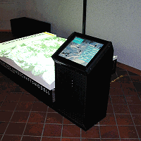
kleinwalsertal tourism board, walserhaus
![]()
| terrain model | |
| multimedia-software | |
| internet-terminal | |
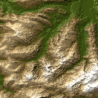
With the Interactive Terrain Model in the Walserhaus, a high Alpine landscape could be worked on in miniature for the first time. The area encompasses the Kleinwalsertal and its surrounding solid mountains, which in reality rise in part to over 3000m. Even for the layman observer, many morphological details are directly obvious on the raw relief, which above all can be traced back to the effects of the glacier formation in the past ice age.
Furthermore, structural features of the geological underground can be recognised. These, and many other aspects are taken up, explained and visualised by the software.The installation is controlled by a 19" touch screen, which is integrated into a very thin terminal.
Digital 3D model of the model area
Data base SRTM-50.
Kleinwalsertal runs approx. SW-NE.