1704 the battle of blenheim
| terrain model | |
| data acquisition | |
| multimedia-software | |
The data acquisition was carried out in close cooperation with the client and a specialist historian (Mr Dr.Junkelmann). For the correct reconstruction of the geographical facts, original maps of the Bavarian land recordings of 1820 were used and geo-referenced approximately.
For the course of the battle itself, there were a variety of period depictions available, which, however, give only conditional spatial reference points over the more than fifteen-hour process. In addition, the historian created over twenty individual maps in minute detail, which depict the battle in stylised and sometimes simplified form. Essentially, this makes up the basis for the full animation.


Period depictions of the
course of the battle
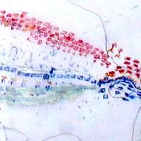
Graphical reconstruction
by Dr. Junkelmann
Above top: Section of the Bavarian
land recordings of 1820